Friday, 12 July 2013

YORKSHIRE IN THE BUFF: CALENDAR GIRLS


I have a confession to make.  For the first thirty years of my life I hardly ventured north of Birmingham.  I grew up in Cornwall, and as far as I was concerned "oop north" was a cold, dark place with sooty, industrial cities and little to tempt me there.  Then, two years into my marriage my husband and I decided to drive to Scotland.  On the way up we stopped in Wharfedale in the Yorkshire Dales, and as we wound our way up the dale with its vast, rolling green meadows with flocks of sheep being rounded up by spirited sheepdogs and its quaint little villages nestling in the folds of the countryside on the banks of the River Wharfe I started mentally kicking myself.  What had I been missing all these years?  This was wonderful.  And so the Yorkshire Dales came to be one of my favourite parts of Britain.  This stunning part of the country is the backdrop to the film Calendar Girls, based on a true story about a group of "women of a certain age" from a local Women's Institute who wanted to create a best-selling calendar to raise money for a hospital in memory of a friend's late husband and who decided to produce a series of tasteful images of themselves in the altogether.

The village where the W.I. held their meetings was called Knapely in the film, but in reality many of the scenes representing Knapely were filmed in Kettlewell in Upper Wharfedale.  For example, the hillside where the ladies did their tai chi was at Leyburn Road in Kettlewell, while John and Angela's house was at Cam Lodge.  Kettlewell lies on the banks of the River Wharfe and the mountains of Great Whernside and Buckden Pike tower over this idyllic scene.  The village was once a thriving market centre, and later grew rich on textiles and lead mining.  The remains of a smelting mill are still visible above the village.  Nowadays, agriculture is the economic mainstay, together with tourism of course, especially with the number of visitors coming to see where the film was made.  Once a year in August the village hosts a scarecrow festival, with scarecrows dotted around the place dressed in different costumes.

File:Town Head - geograph.org.uk - 1441734.jpg
Town Head - geograph.org.uk - 1441734. Photo by John Illingworth, via Wikimedia Commons.
Another location in Wharfedale which featured in the film is Burnsall, where the annual village show, referred to as the "Kilnsey Show" was filmed.  We made a lunch stop at a riverside pub in Burnsall on my "voyage of discovery" en route to Scotland, actually an alfresco lunch even though it was October - so much for the North being cold!  Burnsall is very popular for walking and fishing, and there is a path by the river between here and Hebden dating from Viking times.  There is a handsome five-arched bridge in the village which forms part of the Dales Way long-distance trail.  On our way through the dale, we made an overnight stop at the Tennants Arms Hotel in Kilnsey, not knowing at the time that it was to be used in a future film - the hotel featured in the press conference scenes.  Towering over this small village is a prominent local geographical feature called Kilnsey Crag, a large limestone cliff.  Another beautiful Wharfedale location used in the film is Buckden, towards the north end of the dale.

File:Burnsall Village from the Barden Road - geograph.org.uk - 946841.jpg
Burnsall Village from the Barden Road - geograph.org.uk - 946841. Photo by Doug Elliot, via Wikimedia Commons.

The film used a number of other Yorkshire locations besides Wharfedale:  Coniston, North Yorkshire (not to be confused with the Coniston in the Lake District); Cow and Calf rocks which overlook the town of Ilkley; Settle - southern terminus of the Settle-Carlisle Railway - where Chris (Helen Mirren) goes to the pharmacy to collect the photographs; Ingleton, famous for its WaterfallsTrail and for Ingleborough, the second highest mountain in the Yorkshire Dales; Malham with its spectacular "Cove"; Skipton, where the Calendar Girls try to get sponsorship; and White Abbey, Linton, where the photo shoot took place at Celia's house.  So anyone visiting the area who enjoyed the film can easily fill a week discovering the filming locations while making the most of all that this wonderful part of the country has to offer.

File:IlkleyCowandCalfRocks.jpg
IlkleyCowandCalfRocks. Photo by Jon Farman, via Wikimedia Commons.

For information about the Yorkshire Dales, visit the National Park website.

Map of the Kettlewell area.


Friday, 21 June 2013

UPSTAIRS DOWNSTAIRS IN DEEPEST HAMPSHIRE: DOWNTON ABBEY


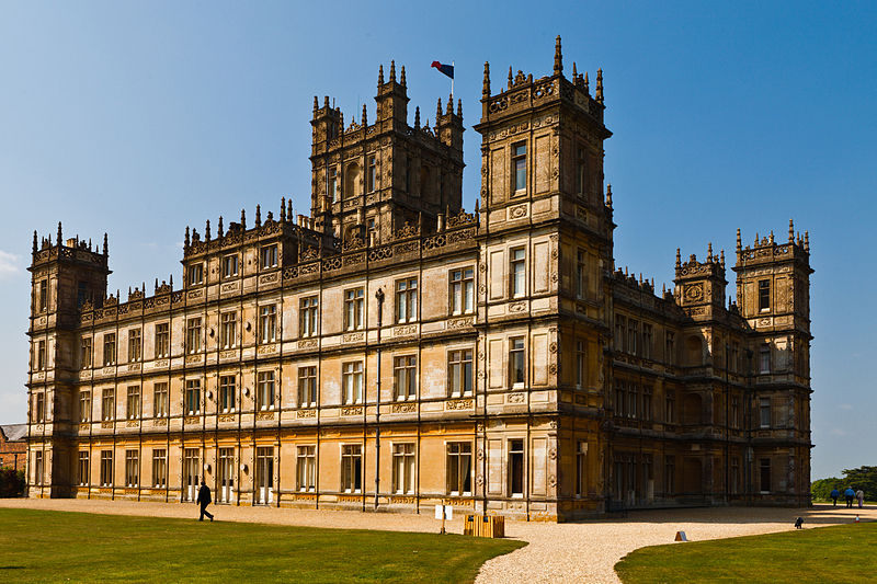
Highclere Castle has become so inextricably linked to the ITV period drama series Downton Abbey that the area surrounding it has been christened "Downtonia".  The hugely successful series, the brainchild of Julian Fellowes, takes us through the emotional rollercoaster that makes up the family life of the aristocratic Crawley family and their servants during the reign of King George V.  The latest series had a suitably dramatic ending as Dan Stevens (playing Matthew Crawley) ruined everyone's Christmas by fatally crashing his car in the show's Christmas special.  The setting of the drama is a fictional estate in Yorkshire which is the seat of the Earl and Countess of Grantham, but the exterior shots and most of the interior ones were filmed at Highclere Castle, apart from certain areas such as the servants' quarters, for which Ealing Studios was used.

The site occupied by Highclere Castle was in medieval times the location of the palace of the Bishops of Winchester.  A house was later built on its foundations, then later still Highclere Castle came into existence: it has been the seat of the Carnarvon family since 1679.  In 1692 Robert Sawyer, a former Speaker of the House of Commons and college friend of the 17th century diarist Samuel Pepys, bequeathed a mansion at Highclere to his daughter Margaret, wife of the 8th Earl of Pembroke.  It was their son, Robert Saywer Herbert who began its picture collection and created the garden temples.  In the mid-19th century, the architect responsible for the present incarnation of the Houses of Parliament, carried out extensive rebuilding work on the house in an "Anglo-Italian" style.  The park surrounding the castle was created according to a design by Capability Brown, and the local village was actually moved during the process: the remains of the original 17th century church are at the south-west corner of the castle.

Visitors to Highclere Castle can luxuriate in the sumptuously decorated rooms open to the public, which include the Saloon, the State Dining Room, the Library, the Music Room, the Drawing Room and the Smoking Room.  Some of the bedrooms can also be viewed, reachable via the suitably impressive oak staircase, as can the kitchens, cellars and so on in the "downstairs" part of the household.   The glorious grounds of the Castle feature the Monks' Garden, whose name is a nod to the Bishops of Winchester, and such delightfully named areas as the Secret Garden and the Wood of Goodwill.  The extensive parkland includes a number of classically inspired follies, as well as remains of ancient Iron Age and Bronze Age hill forts and tumuli.  

File:Highclere Castle (April 2011).jpg

Highclere Castle (April 2011). Photo by Richard Munckton, via Wikimedia Commons.

Probably the most notable episode in the history of the Carnarvon family occurred in 1922, when the 5th Earl of Carnarvon, along with the archaeologist Howard Carter, discovered the tomb of Tutankhamun.  The find was the pinnacle of 16 years spent excavating at several key archeological sites in Egypt.  Sadly, the Earl died the year after the incredible find, but his legacy was an extraordinary collection of antiquities, most of which were sold to the Metropolitan Museum of New York, although a few less significant items remained at Highclere.  Now these and some of the other items have been brought together for an exhibition at Highclere which, as well as displaying some of the fruits of Carnarvon's time in Egypt, tells the story of the quest by Lord Carnarvon and Howard Carter which led up to the discovery of the tomb.  The fascinating artefacts on display include a  noble woman's coffin from 3,500 years ago.

There is one note to add on Carnarvon's death.  One of the best known legends surrounding the antiquities unearthed in Egypt is that of Tutankhamun's curse.  As it happens, it was less than two weeks after the official opening of the burial chamber that Lord Carnarvon was bitten by a mosquito, and the bite became infected.  The Lord fell ill with pneumonia, from which he died, aged just 57.  But that's not all: allegedly, the lights went out in Cairo at the moment of his death, while back home his dog started howling and died at the same moment.  Meanwhile, back in the present, it has been reported that several of the cast members of Downton Abbey had accidents during the filming, resulting in two broken wrists and a foot impaled by a dropped knife.  Perhaps the Curse of Tutankhamun lives on...

The house and grounds are open to the public at peak times of the year and on certain other dates for special events.  Downton Abbey returns to our TV screens later this year.

Highclere Castle is in the far north of Hampshire, near Newbury.  See here for a map.


Monday, 27 May 2013

JANE AUSTEN'S LYME REGIS


Jane Austen's novel Persuasion, which tells the story of love lost and refound, is set largely in the leafy countryside of the West Country, and in the elegant town of Bath.  However, the most dramatic scene in the novel, and the most pivotal to the story, takes place in Lyme Regis, where one of the characters has a nasty accident on The Cobb, the sturdy stone quay which encloses one side of the town's harbour, and is forced to extend her stay there while recovering from the incident.  Even today it is easy to imagine such an accident; I had to exercise great caution walking up and down the Cobb's steps on a recent visit.  In fact there is one set of steps on the Cobb nicknamed "granny's teeth", presumably for their unevenness.  

The Cobb


Lyme Regis, one of the loveliest towns on the Jurassic Coast, so named for the rich fossil content in its cliffs, is an attractive small resort, with a harbour and beach area backed by restaurants and pubs. The town is very hilly, and every street seems to offer a view of the sea.  This was well illustrated by Jane Austen in Persuasion, when she described "the principal street almost hurrying into the water".  However, she was less charitable about the architecture, declaring that "there is nothing to admire in the buildings themselves", a fact I would personally dispute, especially in the case of the lovely little promenade lined with elegant Georgian buildings.

The seafront, with views towards Golden Cap

In Jane Austen's era Lyme Regis was a fashionable place to head for during the summer season (although the action in Persuasion takes place in November, "too late in the year for any amusement or variety").  Those who wanted to take to the water had bathing machines at their disposal.  The machines were hired by the hour and were wheeled out to sea by an attendant.  Sea bathing in those days was not just for fun: it was widely believed that a dip in the briny would cure a range of illnesses.  Dances were held in the Assembly Rooms, sadly now gone and occupied by a car park on the seafront at the bottom of the main street.  As for Jane herself, she is known to have enjoyed at least two summer breaks in the town, in 1803 and 1804, and she evidently became very fond of it, judging from her affectionate descriptions of Lyme and the surrounding area, talking of "high grounds and extensive sweeps of country" and "its sweet, retired bay".  She visited the Assembly Rooms on her second visit, and in a letter to a relative described how she was passed over for the first two dances, but danced with a Mr. Crawford for the second two.  There is an unassuming building in the main street called Pyne House which is believed to have been the one where Jane Austen stayed.

Pyne House
Jane Austen fans who want to follow in her footsteps can join a walking tour courtesy of Literary Lyme, who also do French Lieutenant's Woman tours for fans of John Fowles whose novel of the same name was largely set in the town.  

Lyme Regis is on a regular bus service between Weymouth and Exeter, but does not have a train station.  The nearest station is at Axminster, while Weymouth is reachable by a direct rail service from London.  

Official Tourist Information website.

Map of the town.


Friday, 17 May 2013

ABOUT A BOY: CLERKENWELL


In 1998 a book called 'About A Boy' by the popular British author Nick Hornby appeared on the shelves, and quickly turned into a bestseller.  The story was an unusual but heartwarming tale about an unlikely friendship which develops between a spoilt young man called Will (played by Hugh Grant), who lives a life of leisure courtesy of the royalties from a hit song by his father, and an awkward young boy called Marcus, whose mother, a suicidal hippy vegetarian, dresses him in strange clothes making him a magnet for the school bullies.  Will has a creative way of meeting women involving posing as the father of a fictitious two year old at a single parents' group, and it is this that leads to him meeting the boy of the title and his mother and reluctantly becoming  the lad's mentor in life. 

The film made use of a number of locations around London, but many of the crucial scenes were filmed in Clerkenwell in the London Borough of Islington.  The epicentre of Will's life - his hi-tech apartment - was located in St James Walk; for the purposes of the film a false entrance was specially added to the side entrance of numbers 16-18.  The meeting place for the single parents' group was filmed at Woodbridge Chapel.  Meanwhile, in one of the early scenes, Will briefly considers volunteering at a drop-in centre.  The building whose exterior was used to represent the centre in the film was St James's Church.  


Clerkenwell Green - geograph.org.uk - 650865. Photo by Colin Smith, via Wikimedia Commons.


The name Clerkenwell derives from Clerk's Well: the term "clerk" dates from the Middle Ages, and means a literate person or clergyman.  The well in question is still visible today, albeit as part of a modern building called Well Court on Farringdon Lane.  The district's former existence as a village is evident in the presence of an area known as Clerkenwell Green, which survives to this day, although it is some time since the "Green" actually had any grass.  Clerkenwell has a long and varied history.  During the Crusades, the Knights Hospitallers used Clerkenwell Priory as their Headquarters.  Later, in the 17th century when Clerkenwell became a fashionable place to live, the area's distinguished residents included Oliver Cromwell, who owned a house on Clerkenwell Close.  Around this time, several spas opened up, turning Clerkenwell into something of a resort for the well-to-do.  Tea gardens and theatres provided additional diversion, including Sadler's Wells Theatre, which survives to this day, albeit in a much more modern form.  During the Industrial Revolution a number of breweries, distilleries and printing works sprang up in the area, in fact the oldest printing company in the world, Witherby's, is based in Clerkenwell.  During the post-war period the district's industry went into a decline, and the 1980s saw a period of "gentrification", with affluent professionals moving in, along with a number of upmarket restaurants.

As for the buildings used in About A Boy, Woodbridge Chapel was built in the 1830s for Independent Calvinists, then later in that century it was bought by John Groom, who provided employment for disabled girls making artificial flowers, and the chapel became known as the Watercress and Flower Girls Christian Mission.  Later the chapel was transformed into the Clerkenwell and Islington Medical Mission.  Now it is the Clerkenwell Christian Centre.  The site occupied by St James's Church was the location of the springs which gave Clerkenwell its name.  In the 12th century a nunnery was founded there, which fell victim to the dissolution under the reign of Henry VIII.  In the 16th century the nunnery's church became the Old Church of St James, and its existence proved somewhat precarious, with the steeple falling down twice in 1623.  The New Church of St James dates from 1792.  The interior includes some impressive rococo work, particulary the carved drapery over the organ pipes.  There is a wooden figure of St James over the west door of the Nave. 

Clerkenwell has been used in a number of other well-known films, with one building in particular proving popular with film-makers: the George Farmiloe building at 34 St John Street, dating from 1868 and formerly used as a warehouse for the George Farmiloe and Sons lead and glass company.  Three of the Batman films featured the building as the Gotham City Police Department: Batman Begins (2005), The Dark Knight (2008) and The Dark Knight Rises (2012).  The building also played a pharmacy in the 2010 Leonardo di Caprio film Inception.  Meanwhile, over on TV, the Farmiloe building was used as a safe house in an episode of Spooks.


Clerkenwell, Former George Farmiloe Building, St John Street, EC1 - geograph.org.uk - 756323. Photo by Nigel Cox, via Wikimedia Commons.
 Map of the area.


Monday, 6 May 2013

VILLAGE LIFE: THE PEAK DISTRICT


Approaching Derbyshire from the south, skirting around the massive urban sprawl that is Birmingham, the beer-soaked town of Burton Upon Trent, and the cathedral city of Derby itself, it comes as something of a surprise to suddenly find oneself in the Derbyshire Peak District National Park, which in the south is characterised by rolling hills and dales, while the High Peak in the north is all dramatic, windswept uplands.  Nestled among all this scenic splendour are a range of villages and small towns, several of which were used in the filming of the BBC drama The Village starring Maxine Peake and John Simm, which chronicles the life of a fictional village amid the changing social and political landscape of the early 20th century.  The first series covered the period up to 1920, but there are plans for subsequent series taking the viewer further into the century.

The main village used in the series is Hayfield in the north-west of the national park, which lies at the foot of Kinder Scout, a moorland plateau which includes, at 636 metres above sea level, the highest point in the Peak District.  The village was on the old packhorse route from Cheshire to Yorkshire.  With the arrival of cotton in the 19th century the village spread down the Sett Valley and into Birch Vale.  The village has a range of specialist shops, seven pubs and good walking routes.  Once an important industrial centre, the village is now considered a desirable place to live, with property prices reflecting its popularity.  Each year in May there is a May Queen procession, while nearby Little Hayfield hosts sheepdog trials.  Locations in Hayfield which feature in the series include The Old Vicarage, The Royal Hotel, the cricket club and the Library.  Hayfield's other TV connection is that it was the birthplace of Arthur Lowe, who played Captain Mainwaring in Dad's Army, while at Little Hayfield the Lantern Pike pub was a favourite of Tony Warren, creator of Coronation Street, who used to work on writing the episodes while enjoying a pint or two at the pub.

Hayfield, Derbyshire from the northwest. Photo by Dave Dunford, via Wikimedia Commons.


Edale is another attractive Derbyshire village, and its main claim to fame is that it is at the southern end of the Pennine Way.  The village is on a railway line, and its station was used in The Village.  Edale is also where some of the farm scenes were filmed.   There is a Peak District NationalPark Visitor Centre in Edale.  Another location used in the series is Chapel-en-le-Frith, whose French-sounding name derives from the fact that the original settlement was founded by Normans in the 12th century for the purpose of hunting.  The Normans also built the town's first chapel, now the Church of St Thomas Becket.  The town's Playhouse Theatre was used as the village theatre in the series.  The church in the fictional TV village was actually a church in Glossop.  The Middleton Farm which formed the centrepiece of the drama was represented by Far Coombes Farm in Charlesworth.  Further afield in Cheshire, Tatton Park Farm, which forms part of Tatton Park Estate in Knutsford, was also used in the series.  

File:Edale - geograph.org.uk - 250254.jpg
Edale - geograph.org.uk - 250254. Photo by Stephen Burton, via Wikimedia Commons.

Further information about the Peak District National Park can be found here.

Monday, 22 April 2013

A CIDER-SOAKED IDYLL: LAURIE LEE'S SLAD


Gazing at the bucolic countryside surrounding the village of Slad, roughly midway between Bath and Cheltenham, it is hard to imagine how Laurie Lee could have torn himself away when he "walked out one midsummer morning" to embark on his epic walk through Spain.  In fact, although he was very attached to the village of  his birth, he did feel its limitations, and as well as his foreign escapades, in later life he made regular trips up to London, while maintaining a home and family in Slad.  That said, he found plenty of material from his early life in the village for his best-known work Cider With Rosie, an account of his Gloucestershire childhood with all its ups and downs, from jolly japes at the local school to the loss of a sibling, who died "suddenly, silently, without complaint", not to mention his friendship with the Rosie of the title, who was complicit in Laurie's initiation into cider.  Cider With Rosie was followed by two more memoirs: As I Walked Out One Midsummer Morning, covering the walk through Spain, and A Moment Of War, about his return to Spain to fight for the Republican cause.

The former village school.
Cider With Rosie is full of delightfully graphic descriptions of Slad and the surrounding countryside.  Right in the first chapter he manages to convey not only the sights, but also the sounds and smells of the land outside the family home, Rosebank.  Lee has just arrived at the cottage for the first time at three years old, and he describes the sight of the grass which "towered above me and all around me, each blade tattooed with tiger-skins of sunlight"; the sound of "grasshoppers that chirped and chattered and leapt through the air like monkeys"; and the smell of "the ground, rank with sharp odours of roots and nettles".  The village itself is "a scattering of some twenty or thirty houses", while the roofs of the houses in the sunshine would sparkle "like crystallized honey".   

Rosebank, the house where Lee spent his childhood.

Slad Valley is an idyllic green fold of countryside set among the rolling hills of the southern Cotswolds.  The village has just one pub, The Woolpack, which is just across the road from where Laurie Lee and his wife Kathy used to live.  Lee was a regular visitor to the pub, which gets a mention in Cider With Rosie, and which makes the most of its associations with the writer with pictures on the wall and even a beer produced by the local Uley Brewery named after him.  The village church, where Lee used to sing in the choir, is also by the roadside.  The school he attended is also still there, although it is no longer a school, having been converted to a house.  The village is ranged over one side of the valley, and in the lower part is a small lake next to which is Rosebank, which the Lee family rented for princely sum of three and sixpence a week.  The Slad Valley has repeatedly been threatened with housing development.  Laurie Lee helped to fend off one such development during his lifetime, but more recently there has been another attempt to develop the area.  Happily for this beautiful corner of the Cotswolds it was reported just the other day that the plan for a housing estate in the valley is likely to be rejected.

Holy Trinity church.

The Woodpack.

A short distance from Slad is the town of Stroud, where Laurie Lee started attending the Central School when he reached twelve, and where he later worked as an office boy for a firm of chartered accountants.  Stroud is a hilly market town with a range of independent shops; it prides itself on its commitment to all things organic, and was in at the start of the Organic food movement.  It also has a thriving artistic community; Jasper Conran once referred to the town as the Covent Garden of the Cotswolds.  During the industrial revolution the town's economy centred on textiles, and at one point there were 150 mills in the surrounding valleys.  Many of the former mills, although no longer serving their original purpose, have been taken over by small businesses.  

Laurie Lee's gravestone. The inscription reads "He lies in the valley he loved".  He died in 1997.

Map of the area.


Saturday, 6 April 2013

BRIGHTON ROCKS: QUADROPHENIA


People who complain about the youth of today should cast their minds back to Britain in the early to mid 1960s, when seaside towns such as Margate, Clacton and Brighton were terrorised by the opposing youth subcultures known as Mods and Rockers.  Bank holiday weekends were a particlar flashpoint, when hordes of Mods and Rockers would flood into these resorts on their favoured mode of transport and dressed in their preferred gear: motorbikes and leathers for Rockers, scooters and suits with parkas for Mods.  These occasions would inevitably end in open warfare between the two factions, who engaged in fighting in the cafes and on the beaches, sending terrified pensioners fleeing from their deckchairs.  Newspapers of the day were full of reports of incidents such as "fighting on the sands" (Margate), a "second Battle of Hastings", and a  "running battle with police" (Brighton).  This youth phenomenon is what forms the cultural backdrop to Quadrophenia, a film version of the rock opera written by The Who's Pete Townsend in 1973, and transferred to the big screen in 1979.

The troubled main character, Jimmy (Phil Daniels), lives in London, but the climax of the film occurs when he heads for Brighton on a Bank Holiday jaunt with his Mod friends, including Steph, played by Lesley Ash, the object of Jimmy's desires.  On their arrival in the resort, the Mods, together with their scooters and girlfriends, converge on Madeira Drive.  At one point, all heads turn at the sight of the god-like blonde-haired Ace Face, played by Sting, who oozes cool, riding into town accompanied by a posse of scooters.  Towards the end of the film he appears again looking rather less cool, dressed in a ridiculous bell-boy outfit, in his job as a porter at the Grand Hotel.  The exterior of the Brighton Sea Life Centre was used as the dance hall where Jimmy spends an eventful evening culminating in his ejection by the doormen after diving into the dancefloor crowds from the balcony.  The next morning finds Jimmy sitting pensively on the beach.  This is one of the most visually memorable scenes from the film: the sun shimmering on the sea, the waves crashing onto the shore, and the pier looking magnificent in the background, and all to the accompaniment of Love Rain O'er Me by The Who.  Later that day the big battle between the mods and rockers takes place, during which Jimmy and Steph escape to an alleyway, where he manages to consummate his passion for her.  The alleyway in question was just off East Street, and is at the back of what is now a fish restaurant.  

Palace Pier, Brighton - geograph.org.uk - 1590780. Photo by Stephen Richards, via Wikimedia Commons.


After the bank holiday episode, a series of unfortunate events contribute to Jimmy's descent into madness and his departure back to Brighton, where he spots Ace Face in his bellboy outfit and makes off with his scooter.  The shocking final scene has Jimmy roaring up to the top of Beachy Head on the stolen scooter and flinging himself and the scooter off the top of the white cliffs.

Beachy Head and Lighthouse from the track up to Belle Tout - geograph.org.uk - 756553. Photo by Simon Palmer, via Wikimedia Commons.


Brighton, the premier resort on Britain's south coast, has been described as London-on-sea, due to its relative proximity to the capital. The resort used to have two piers, the Palace Pier and the West Pier, but the West Pier burned down in 2003.  Madeira Drive is a raised seafront road which runs eastwards from Brighton Pier.  The Drive is used as the "finish line" for many road races involving a variety of vehicles such as veteran cars, motorcycles and cycles.  The Palace Pier, which started life as a Chain Pier in 1823 acting as a landing stage for passenger ships from Dieppe, is a classic example of its genre.  Seaside resorts all over Britain have piers like this, most of them built during Victorian times when visits to the seaside gained massively in popularity, helped along by the emerging railways.  The piers provided both entertainment and a chance for people to walk out over the sea without the hassle and worry of getting into a boat (which was a much bigger deal in those days than it is now).  Not surprisingly, given the unpredictable British climate, these structures have proven vulnerable to the elements, often suffering extensive damage as a result of storms.  The Palace Pier was battered by numerous storms in its early days, culminating in a monster storm in 1889 which caused such extensive damage that the pier had to be completely rebuilt.

The most famous of Brighton's many hotels is the Grand  Hotel.  The hotel has long enjoyed the status of grand old lady of the Brighton seafront.  Built in 1864 for moneyed visitors to the resort, one of its most notable features was a  "vertical omnibus" or hydraulically powered lift.  The hotel's darkest hour came in 1984, during a Conservative party conference, when the IRA bombed the hotel in an attempt to assassinate Margaret Thatcher.  She survived the attack, but five people died and several were injured, including Cabinet Minister Norman Tebbit.

Brighton's seafront is modern in appearance, but just behind it is the charming labyrinth of streets known as The Lanes.  Just to the east of the Lanes is Brighton’s most famous landmark, which looks as though it belongs not only to a different age, but to a far-flung country. The Brighton Royal Pavilion was started by John Nash in 1787 as a seaside home for the Prince Regent, and was made to look like an Indian palace, making it comically incongruous with its riot of domes and other exotic Indian features.  In the late 1800s, Magnus Volk, son of a German clockmaker, who was born in Brighton, built a tourist attraction which was a rival in eccentricity even for the Pavilion. Nicknamed the “Daddy Longlegs”, it was a “Seashore Electric Tramroad” consisting of a vehicle with 24-foot long legs, each with four wheels on the end, with two open decks, which could carry up to 150 passengers for 3 miles along the seafront to neighbouring Rottingdean. It was powered by electric cables which ran along a row of wooden poles. Sadly, this bizarre example of 19th century inventiveness was destroyed by a severe storm one week after opening, although it was rebuilt, only to close again in 1910. One of Volk’s earlier projects, however, was much more long-lived, in fact it still runs today: Volk's Electric Railway. During the summer months it is possible to travel on this eminent piece of engineering from the Aquarium to Black Rock.

The Royal Pavilion Brighton. Photo by Peter Greenhalgh, via Wikimedia Commons.

To the east of Brighton is Beachy Head, one of the most famous headlands on Britain’s south coast, with the highest chalk sea cliff in the country, rising to a height of 162m.  This is a place tinged with sadness, being a popular place for suicides and attempted suicides, reckoned to number on average 20 per year.  Add to that the loss of life from maritime accidents just offshore, and one shudders to think of the number of lives lost at the hands of Beachy Head.  A collision in 1889 between the British vessel Largo Bay and a steamer called the Glencoe resulted in 54 dead, more than half of them Chinese.  In 1912 the P & O liner Oceana collided with the German barque Pisagua resulting in 9 lost lives.  These are just two examples. Add to this the wartime toll, including the torpedoing of the steamer Haipolian in 1915, and it is hard to conjure up positive feelings about this headland.  One of Beachy Head's most famous features is the jaunty red-and-white striped lighthouse at the foot of the cliff.