Sunday, 10 July 2016

GOING FOR GOLD: CHARIOTS OF FIRE, ST ANDREWS


It seems hard to believe that four years have gone past since the nation and the world witnessed the stirring spectacle of the London 2012 opening ceremony.  The most memorable part of the ceremony was the spine-tingling sequence representing Britain’s Industrial Revolution, but prior to that there was a comedy sketch involving British comedian Rowan Atkinson playing a pianist with a repetitive role in a performance of the theme music to Chariots of Fire, a film made in 1981 but re-released in 2012 prior to the London Olympics, which tells the story of two athletes who, after years of training, are accepted to compete in the 1924 Paris Olympics.  The film triumphed at the 1982 Oscars, winning four awards including Best Picture.  The music also earned its Greek composer Vangelis an Oscar for Best Original Score. 

Anyone who has seen the film will remember the scene near the beginning where, with the theme music as a backdrop, the athletes raced along a glorious sandy beach in their white period racing gear, their feet splashing in the shallows.  In the 2012 opening ceremony Rowan Atkinson’s mind wanders off during his boring part of the musical performance and he starts fantasising about being a part of the beach scene.  Some clever camera trickery is used to superimpose him on the scene alongside the original actors.  Ben Cross, who played Jewish athlete Harold Abrahams in the film, described the act of running along the sand as ‘hell’.  Worth enduring though, for what has come to be one of the most iconic scenes in British film, so much so that people can often be spotted recreating the scene on the beach.  

So where was this beach?  Well in the film it was meant to be Broadstairs, but in fact, the scene was shot at West Sands in St Andrews, Scotland’s answer to Oxford, famous for its university and the fact that the Duke and Duchess of Cambridge met there.  Famous also for its fine golf courses, one of which was founded in 1754 and is regarded as the home of golf.  St Andrews was chosen as a cost-saving measure, due to the fact that other scenes were being filmed elsewhere in Scotland.  Filming on a beach is not without its problems: the story goes that the crew were forced to return to the location to film the sequence again because sand had got into the camera the first time round, damaging the negatives.

File:West Sands Beach, St Andrews - geograph.org.uk - 1803950.jpg
West Sands Beach, St Andrews - geograph.org.uk - 1803950. Photo by Stephen Sweeney, via Wikimedia Commons

The production crew had to change the outward appearance of some of the city’s newer buildings to make them look more in keeping with the period.  Towards the end of the beach sequence an imposing building can be seen near the golf course, with the name Carlton Hotel on it.  The building was used as a University residence at the time but was relabelled for the film.  Sean Connery reportedly joined the film’s producer David Puttnam at a screening of the film, and when the building came into view he tapped Puttnam on the shoulder and said “That’s not the Carlton Hotel, that’s St Andrews”.  Apparently a lot of the extras used in the filming were recruited the night before from the local bars.  

File:St Andrews Golf Links from The Scores - geograph.org.uk - 305228.jpg
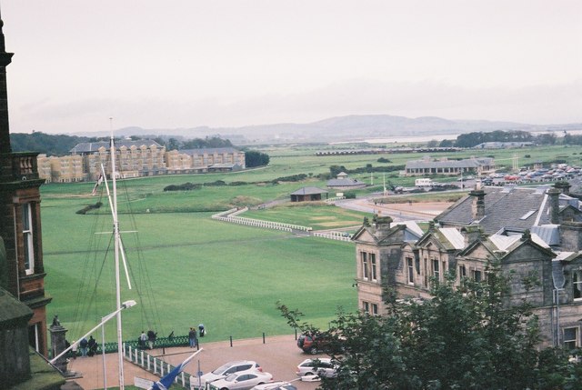
St Andrews Golf Links from The Scores - geograph.org.uk - 305228. Photo by Rob Bishop, via Wikimedia Commons

Although the city did not form a part of the film’s story and, Connery aside, many people would not have recognised it in the beach scene, St Andrews is evidently determined not to forget its role in the film, with a plaque commemorating the filming and a hotel bar called Chariots.  There is also an annual Chariots of Fire fun run on the beach, giving fans of the film a chance to relive the scene.

Map of the area.


Sunday, 12 June 2016

POOH TERRITORY: ASHDOWN FOREST, EAST SUSSEX


I have been a prolific reader ever since I can remember, and one of my fondest literary memories from my childhood is the series of books featuring an overweight, honey-guzzling bear called Winnie-the-Pooh, or Pooh.  The stories, by A. A. Milne and written in the 1920s, followed the adventures of Pooh and a host of other lovable animal characters, including the diminutive Piglet, the morose donkey Eeyore and the excitable Tigger.  The token human, Christopher Robin, was based on the author’s son Christopher Robin Milne, who grew up on the family farm in the village of Hartfield, between Royal Tunbridge Wells and East Grinstead. 

The scene of the action is Ashdown Forest adjoining Hartfield .  Within the forest is the Five Hundred Acre Wood, which features in the Pooh stories as ‘Hundred Acre Wood’ or ’100 Aker Wood’.  The characters frequent a number of locations within the wood, for example ‘Owl’s House’.  There is a car park on Gill’s Lap (Galleon’s Lap in the stories) where there is a map of the surrounding area showing some of the key locations from the stories.  

File:Ashdown Forest, Milne memorial, Gill's Lap 02.JPG
Ashdown Forest, Milne memorial, Gill's Lap 02. Photo by Poliphilo, via Wikimedia Commons

Hartfield itself is home to Pooh Corner, which runs an online shop selling Pooh merchandise, and there is also a tearoom there.  Nearby is a stream which eventually runs into the River Medway, and crossing the stream is the famous Poohsticks Bridge, where the game Poohsticks was invented by A A Milne for his son Christopher Robin.  The game involves people lining up on the bridge and dropping sticks into the water.  They then rush to the other side of the bridge and the owner of the first stick to emerge is  the winner.  The game is still kept alive today, and world championships in the 'sport' have been held.  

File:Goodnight Pooh - geograph.org.uk - 1048150.jpg
Goodnight Pooh - geograph.org.uk - 1048150. Photo by Ian Paterson, via Wikimedia Commons

At the south-east corner of the Hundred Acre Wood is a spot described as “rather boggy and sad”.  This is Eeyore’s Gloomy Place, where the sad old donkey lived in a stick house prone to falling down.  The Milne family kept a donkey called Jessica in a pasture, and it is thought that this provided the inspiration for Eeyore’s Gloomy Place.  Meanwhile, at the entrance to the farm itself is a walnut tree where Christopher Robin built a trap which ensnared the foot of the gardener’s wife.  This was the inspiration for the story about the Heffalump trap built by Pooh and Piglet to ensnare the mythical elephant-like beast.

Ashdown Forest was once a medieval hunting forest which was created soon after the Norman Conquest.  Today it is the largest area of open access land in the south-east, running at 9.5 acres of beech woods and open heath with wonderful views of the High Weald Area of Outstanding Natural Beauty, making it a popular destination for walkers.  As well as the resident sheep and horses, there is a large deer population and there are also ground nesting birds, so walkers need to keep any dogs under control.  

Map of the area.


Tuesday, 24 May 2016

SHIPS AHOY! THE ONEDIN LINE: DARTMOUTH AND GLOUCESTER


One of the best drama series to hit our TV screens in the 1970s was The Onedin Line, which charted the fortunes of a 19th century shipping line.  The stirring theme music set the scene for this maritime epic, starring the late Peter Gilmore as James Onedin and Anne Stallybrass as his wife Anne, which gave a fascinating insight into seafaring life at the time, both at sea and on shore.  The shore base of the shipping line was meant to be Liverpool, but much of the filming took place in Dartmouth, while many of the dock scenes were filmed in Gloucester Docks (moving to Pembroke Dock for the last series).  Dartmouth’s historic riverfront, with its reminders of the town’s seafaring past, made a convincing backdrop for the filming of a story set during this period, while the massive 19th century waterside warehouses of Gloucester Docks, overlooked by the majestic tower of Gloucester Cathedral, served equally well for the shore-based scenes.

The action filmed in Dartmouth centred around Bayards Cove and the surrounding picturesque streets.  The 16th century fort at Bayards Cove was used as a gun emplacement intended as an additional line of defence to the Dartmouth and Kingswear castles, which face each other at the mouth of the Dart.  The fort was deliberately sited at the narrowest point of the channel forming the entrance to the harbour.  In the period leading up to the construction of the fort, Dartmouth had developed into an important trading port, serving the wine trade with France, and later on the cloth trade.  The town went into a decline in the 18th century, and with it the fort, but its fortunes were revived with the opening of the Naval College and the town’s popularity as a tourist destination.  The fort is now owned by English Heritage, who also own the castle.  

Dartmouth's waterfront

As well as the town’s historic sights, Dartmouth’s main appeal is its beautiful river.  Boat trips are available, some of them linking Dartmouth with Totnes, an attractive market town further upstream.  There is a steam railway on the Kingswear side of the estuary offering trips to Paignton, and tickets combining this with the boat trips are available.  The town itself is an appealing mix of pubs, restaurants, cafes and shops.  Dartmouth Museum is housed in the row of houses known as The Butterwalk, built in the 1630s as merchants’ trading houses.  

Dartmouth Castle

It was the 1827 opening of the Gloucester and Sharpness Canal, linking the city to the mouth of the River Severn and the Bristol Channel beyond, which led to Gloucester taking off as a trading port in the 19th century.  The docks’ facilities steadily grew during the course of the century, with the arrival of the railway in the 1840s providing a further fillip.  By the second half of the century goods were being imported from Northern Europe and the Black Sea ports, and even as far afield as North America and the Russian Arctic.  The produce reaching our shores via Gloucester ranged from timber to wines and spirits and even guano for fertiliser.  In the early 20th century steamers began running services from Gloucester to ports on the Continent.  It was the increasing size of many of the vessels which eventually contributed to the decline of the docks.  

File:Docks in Gloucester.JPG
Gloucester Docks

Nowadays, it is largely pleasure craft that make use of the facilities, with traditional canal barges rubbing shoulders with river cruisers in the 50-berth marina.  Anyone wanting to relive the glory days and immerse themselves in the Onedin Line experience should visit during the Tall Ships Festival, when visitors get the chance to view these evocative vessels at close quarters.  In the last few years, particularly since last year when the city hosted some of the Rugby World Cup matches, Gloucester Docks has really taken off as a tourist attraction, with Gloucester Quays Outlet shopping centre, a host of bars and restaurants, and a Waterways Museum from where tickets can be purchased for a boat trip along the canal.  There are also a number of other events each year besides the Tall Ships Festival, including a Food Festival, a Sea Shanty Festival and a Victorian Christmas Market.

Map of Dartmouth.

Map of Gloucester.


Friday, 22 April 2016

CASTLES FIT FOR THE BARD: ZEFFIRELLI'S HAMLET


April 23rd this year marks the 400th anniversary of the death of Shakespeare, Britain’s most famous playwright.  To mark the occasion, I thought we’d take a little tour of the castles used in the 1990 production of Hamlet starring Mel Gibson and directed by Franco Zeffirelli, one of many films based on the stories by the man affectionately known as “The Bard of Avon”. 

The story of Hamlet is set in the 14th and 15th centuries, and the main focus is on the fictional town of Elsinore, Denmark, although Shakespeare himself never actually went to Denmark as far as we know.  The castle of Elsinore referred to in the play, which is the home of Hamlet and his family, is probably Kronborg Castle in what is today known as Helsingør, a port on the east coast of Denmark facing Sweden.  For the purposes of the 1990 film, Elsinore Castle was represented by Dover Castle.  According to an article which came out around the time of filming, Mel Gibson said he had never been colder than when filming at Dover Castle. 

The castle has had a long, eventful history.  The site started off as an Iron Age hill fort, and one of the oldest elements still on display is the remarkably well-preserved Roman lighthouse.  When William the Conqueror burst onto the scene after his victory at Hastings, he turned the site into a Norman earthwork and timber-stockaded castle.  The castle we see today was started off as a medieval fortress by Henry II, and comprises a keep 83 feet high with walls of a thickness befitting the castle designed to defend the gateway to the realm.  Royal visitors to the castle have included Henry VIII and Elizabeth I.  Of course, the other feature for which Dover is famous is the towering White Cliffs surrounding the town.  One of these is called Shakespeare Cliff, so named because it was mentioned in King Lear, which was partly set around Dover.  Another castle in Kent which made an appearance in the film is Rochester Castle.  

File:Dover Castle 05.jpg
Dover Castle 05. Photo by Jake Keup, via Wikimedia Commons.

Zooming northwards to Scotland, there were two Scottish castles used in the film.  Both internal and external scenes of Elsinore Castle in the film were shot at Blackness Castle, set on the shores of the Firth of Forth between Falkirk and Edinburgh.  The scene featuring Ophelia's first appearance in the film was shot in the large hall in the Stern tower. The entrance to the tower, the courtyard next to it and the battlements also feature.  The castle was built in the 1440s by the Earl of Caithness, and in 1453 it was seized by King James II and it acted as a state prison for over 250 years.  Further fortifications were added in the 16th century.

File:Blackness Castle - geograph.org.uk - 1185379.jpg
Blackness Castle - geograph.org.uk - 1185379. Photo by James Denham, via Wikimedia Commons.

Set on top of an impregnable rock separated from the mainland by a ravine, Dunnottar Castle near Stonehaven is one of the most impressive sights on Scotland’s east coast.  The makers of Hamlet evidently agreed, as there are many shots of the castle from a distance – once again standing in as Elsinore Castle.  Towards the end of the film the base of the cliffs on which the castle stands were used for the cemetery scenes.  The present day ruins date from the 14th century, though it is thought that the castle’s origins lie in the arrival of St Ninian in the 5th century, when he chose the site for one of a chain of churches.  In spite of its seemingly inaccessible position, the castle can still be visited today via a path leading up to a tunnel entrance, but the access path is steep, so not suitable for everyone.  
File:CMSJ IMG 0217 (640x480) (3869554185).jpg
CMSJ IMG 0217 (640x480) (3869554185) (Dunnottar Castle). Photo by Carlos Menendez San Juan, via Wikimedia Commons.